Gattung: |
|
||
Autor/Herausgeber: |
Emanuel Bowen Normierte Form: Bowen, Emanuel |
||
Titel:
|
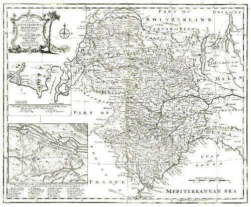
A New and Accurate Map of Savoy, Piemont, and Montferrat. Exhibiting the present Seat of War. Collected from the best Authorities and most approved Modern Maps. The wole being regulated by Astron. Observations. By Eman. Bowen
Normierte Form: |
||
Sammelband: |
A complete Atlas, or distinct view of the known World | ||
Erscheinungsjahr: |
[1745] | ||
Ausgabebezeichnung/Auflage: |
Incisione | ||
Erscheinungsort: |
[London] Normierte Form: London [Londres] |
||
Format: |
mm. 355 x 434 | ||
Besitznachweis: |
Archivio Storico della Città di Torino, coll. cartografica, 185 | ||
Schlagwörter: |
Westalpen - Geographische Karten - 1745 |
||
Inhaltsverzeichnis: |
Titolo in alto a sinistra, entro un cartiglio decorato con scene di caccia. Sotto al titolo, due riquadri raffiguranti i porti di Nizza e Villefranche, con il titolo "A Draught of the City of Nice and Town of Villa Franca", e la pianta della città di Cuneo, con il titolo "A plan of Coni a Strong fortified City, situated on a Hill between two Rivers, which renders its approach on the East and West sides very difficult". |
||
Zusammenfassung/Kommentar: |
Le Valli valdesi sono indicate come: "Pro. of the 4 Valleys Vaudois", e presentano numerosi toponimi. Bibliografia: F. Barrera, Il Piemonte nella cartografia del Settecento, n. 34 ; L’immagine delle Valli valdesi, n. 41 ; Torino e il suo orizzonte, n. 127. |
||
Su concessione dell’Archivio Storico della Città di Torino |